
CEDAR Strategic Plan
 November 2013 Strategic Plan Addendum
Addendum to the New Dimension document
June 2011 CEDAR Strategic Plan Document
CEDAR The New Dimension, Strategic Vision
CEDAR Strategic Plan Draft and Presentations
CEDAR Strategic Plan V9.2 Document, Draft Oct 2010
CEDAR 2010 Workshop - CEDAR: The New Dimension
CEDAR 2009 Workshop - Strategic Plan Presentation (revised)
CEDAR Strategic Planning for the Next Decade
Motivation for a CEDAR Strategic Plan
- CEDAR Phase III document is from 1997
- Research landscape is rapidly evolving
- Initiatives are pushing the research and resource envelop of CEDAR
- CEDAR needs to be better poised to contribute to high-priority, agency-wide research programs
- CEDAR has icon status as the preeminent aeronomic body and is the right group to push concept forward
Benefits of the Strategic Plan
- Unifies the Aeronomic field
- Demands stronger collaboration with other research areas, such as lower atmosphere and magnetosphere
- Explores transformational research
- Defines resource needs
- Responds to the new research landscape
- Provides a platform from which new initiatives can build
Overarching Problem Statement: What are the geospace impacts on Earth’s habitability and sustainability of technology-reliant societies?
"Man must rise above the Earth – to the top of the atmosphere and beyond – for only thus will he fully understand the world in which he lives.” — Socrates
Themes
The following themes are at the heart of the strategic plan
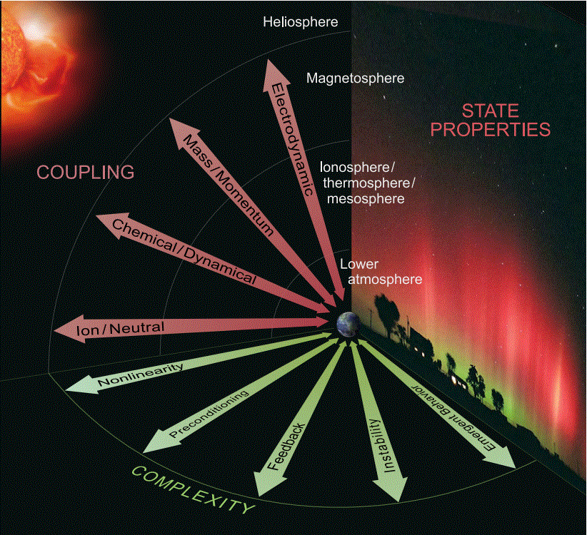
- Variability in the Space - Atmosphere Interaction Region (SAIR) is driven among others by space-atmosphere fluxes, space-atmosphere coupling, and space-atmosphere evolution.
- System Science Perspective: The systems approach transcends the concept of scale, enabling the characteristics of a complex, non-linear system to be generally applied to many problems in the Sun-Earth system.
- Complexity: System complexity is comprised of many interacting elements, which influence one another through nonlinear, dynamical pathways, feedback, preconditioning, cross-scale coupling, instabilities, emergent new behavior.
The Way Forward with Strategic Thrusts
Strategic Thrust #1: Encourage and Undertake a Systems Perspective of Geospace
Mission: To understand global connectivities and causal relationships involving the SAIR and to determine their influences on the interaction region and the whole Earth system. The ultimate goal is to contribute to a holistic model of the Earth system that includes all interacting components from the Earth’s core to geospace. This effort is aimed at predicting future conditions with the accuracy and reliability needed to explore methodologies for continued human wellbeing and sustainable technological development of our planet. Implementation:
- Investigate the applicability of formal systems-theoretical methodologies to better understand complexity in the SAIR
- Explore system characteristics of the space-atmosphere interaction region in terms of nonlinearities, preconditioning and memory, feedback, instabilities, emergent behavior, and cross-scale coupling
- Augment the review criteria for the annual CEDAR proposal competition to include consideration of systems science formulation, and encourage organizers of the Annual CEDAR Workshop to highlight research that emphasizes a system science approach or view.
Strategic Thrust #2: Explore Exchange Processes at Boundaries and Transitions in Geospace
Mission: To understand the transformation and exchange of mass, momentum and energy at transitions within the ITM and through boundaries that connect with the lower atmosphere and the magnetosphere. Studying these transitions and boundaries in terms of physical processes enables new knowledge about the nature of our Interaction Region applicable to Earth and other planetary bodies. Implementation:
- Characterize sources and sinks internally and externally to the SAIR and their possible variations due to the coupling and complexity of the Sun-Earth system.
- Advance theories and coupled models that account for processes at transitions and across boundaries
- Develop computational resources, techniques, and analyses enabling predictive capabilities that incorporate boundary and transitional effects
Strategic Thrust #3: Explore Processes Related to Geospace Evolution
Mission: To understand and predict evolutionary change in the geospace system and the implications for Earth and other planetary systems. Implementation:
- Conduct studies to identify and isolate observables that most significantly influence long-term changes in geospace conditions
- Ensure calibration and validation of relevant observations for reliable identification of long-term trends
- Develop funding and observing models to maintain and improve long-term databases that have become the hallmark of CEDAR science for many years
- Conduct studies of comparative planetary aeronomy to advance physical understanding of atmospheric evolution
Strategic Thrust #4: Develop Observational and Instrumentation Strategies for Geospace System Studies
Mission: To develop instruments capable of measuring system properties necessary to examine the coupling mechanisms and complexity within the SAIR. To exploit existing and planned observational assets in order to optimize scientific return. Implementation:
- Coordinate multi-platform observational campaigns that take advantage of existing and new instrumentation and facilities
- Conduct studies to determine the optimum type and placement of large observatories or instruments and plan for strategic deployment of future instruments that best serve the needs of the CEDAR community
- Develop smart sensors (i.e., autonomous, reconfigurable, robust, low-power, etc.) that optimize measurements in response to changing geophysical conditions
- Pursue the advancement of innovative, space-based sensing platforms, including small satellites, suborbital rockets, and large space missions for CEDAR research
Strategic Thrust #5: Fuse the Knowledge Base across Disciplines in the Geosciences
Mission: To promote collaborations in related but distinct disciplines of geosciences, mathematics, engineering, and physics to attract a greater variety of researchers and students spawning new ideas and methodologies that will more rapidly advance geospace studies. Implementation:
- Promote broader, interdisciplinary participation at the Annual CEDAR Workshop
- Coordinate with other geospace communities as well as engineering mathematical, and computational science communities to enhance CEDAR research and encourage collaborative pursuit of cross-disciplinary funding opportunities
- Work with the International community and organizations, such as CAWSES, ICESTAR, EISCAT, EGS, AOGS, etc., to formulate strategic approaches that address global issues
- Provide an interdisciplinary educational, research and technology framework, including curriculum development, that excites, trains, and supports future generations of researchers in the field
Strategic Thrust #6:Manage, Mine, and Manipulate Geoscience/Geospace Data and Models
Mission: To tap the vast resources of burgeoning geoscience data to provide a new view of geospace, optimize information for proper deployment locations of key instruments and measurements to further scientific productivity, discover correlations and contribute to understanding their causalities, contribute to determining the evolution of geospace by manipulation and evaluation of multiple observables over extended observing periods. Implementation:
- Implement standardized data formats and calibration procedures that will facilitate data acquisition and the establishment of accessible and user-friendly databases
- Continue to evolve data assimilation schemes to integrate data with physics based models for improved predictive capability
- Develop advanced analysis techniques needed for effective fusion of observations into sophisticated inference models
- Develop automated pattern analysis, detection, recognition, tracking, and reconstruction techniques for application to CEDAR data